bobspirko.ca | Home | Canada Trips | US Trips | Hiking | Snowshoeing | MAP | About
A Conversation with Alan Kane, author of Scrambles in the Canadian Rockies – Part 2 |
The following photos were taken by Alan Kane
|
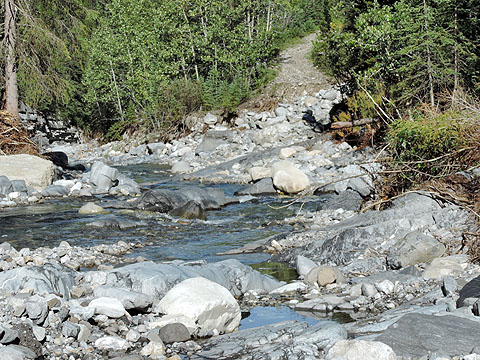
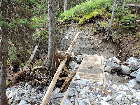
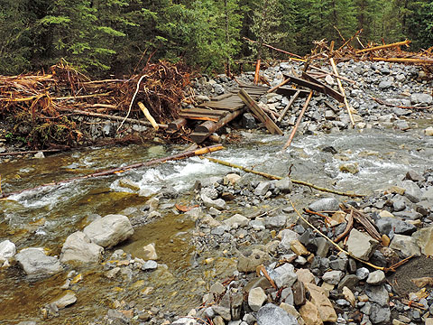
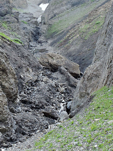
In the days leading up to June 20, 2013, Alberta experienced heavy rainfall that led to catastrophic flooding, the worst in the province's history. As well as causing extensive damage and forcing mass evacuations in Alberta cities and towns, the devastating floods tore into much of the front range mountains. It destroyed roads and bridges, altered rivers and creeks, buried hiking trails under rocks and debris, and carried away footbridges. Many of Alan Kane's approaches for his scrambles were seriously affected. In short, the floods swept away his plans for an easy update to his book, and he was left scrambling – strangely in both meanings of the word – to inspect the impact on his routes. Many of them would have to be studied and possibly be rewritten. But Alan tackled the project with fervor. Like a dormant volcano suddenly triggered, he erupted in a flurry of activity.
Kananaskis Country, which contains a large chunk of Kane scrambles, was especially hard hit. But before anyone could venture into the park, they had to wait until bridges and roads were repaired. Virtually the entire park was closed. A few weeks after the flood, when some sections of Kananaskis opened, Alan had a chance to survey the aftermath. On July 22 he emailed me: Have you been out to K-Country yet? I was out on the weekend. It's quite a sight – impressive how much they've fixed and how fast. I might end up removing a few scrambles from my book due to the flood damage. Three come to mind: Mount Bogart since the trail is gone, Mount Hood since King Creek canyon may be impassable now, and Mount Fisher as I doubt there is any road left going in there. Sort of a setback for updating my book. The rain will undoubtedly change some scramble terrain overall. Some descent gullies on peaks will be a bit different now. Heavy rains higher up seem to have cleaned out small debris in gullies and replaced it with bigger rocks and deadfall further down. In some cases, water surges removed rubble that had been covering steepish slab in gullies making an easy descent more problematic. I guess people will discover those things over time, wherever they occurred. On Sunday I went to check Mount Buller trail (not bad at all) and decided my description was lacking. Even I wasn't sure I was headed in the right direction to reach the high col, so I rewrote it last night while it was still fresh in my mind. On July 31 he wrote: I'll probably spend more time in K-Country than elsewhere. Quite the repair job they've done on roads, bridges and parking lots for sure. I got my picture of Mount Chephren from the bump south of it yesterday (about 20 photos!), and a better one of Sunwapta Peak from across the gravel flats too. Also a better one of Little Hector the day before. Today I went to Rummel Lake to get another picture of The Tower and did some fly-fishing while there (got five cutthroats). I had to come back from vacation tonight to pick up the mail as my wife is down east. I needed a shower anyway. 20 photos of Mount Chephren! His extensive picture-taking added another turn in the development of his new book. With his new camera Alan was taking pictures with abandonment and now planned to add more photos to his book. Let's hope they're not all of Chephren! Meanwhile he continued to check approaches. On August 8 he wrote: I went up Stewart Creek and Exshaw Creek. The debris washed down really takes the fun out of those ones, not the kind of hike you'd do for no good reason now. It adds much time and effort. Exshaw Creek isn't quite as bad as Stewart Creek. The last time those landscapes were like that would have been about 11,000 years ago, just after the glaciers receded, so we will all be long gone before nature mellows them out again. I was going to hike toward Mount Fable, but the side valley to it had so much debris I didn't even recognize it and walked way past it. The traverse from Gap Peak via your route and even back the same way may be preferable now. On August 30 he wrote of other excursions: I've been on vacation again. I came home to dry out after getting soaked returning from Evan Thomas Creek area today. The fire road isn't as bad as I expected, but I got fooled at a washed-out side valley and missed the proper route about 7.5-8 km up there. Might go back tomorrow. My back has been really good the last few weeks. Yesterday I went up Tower of Babel for some pics and in the evening went to the upper lift station at Norquay to see the easier route through the trees behind the lift station versus the steep wall with solution pockets. I made it up there in 35 minutes, not bad for an old guy. I think I saw where the via ferrata is too. There is a rope hanging down with bolts in the rock right above the lift station. Sim and I went up King Creek Ridge last weekend and then down to the col leading to Mount Hood. Then we climbed to the base of the gully to Brock-Hood col to see what that would be like for an approach to Mount Hood. I believe it's better than what King Creek is now for an approach. We did most of Nihahi Ridge recently and about 90% of Mount Evan Thomas (which I did once years ago) and then Grizzly Peak on the way down. Did almost 1500 m that day and my back was okay. Hope it lasts. No fishing lately, maybe next week – except I'm having fun doing all this scree bashing and not getting a sore back from it. That was the other thing that will make Alan's next book a major update: his back never failed him, never put him out of action. Fit and energetic, he was able to meticulously research his peaks. While studying numerous routes and taking countless photos, he hiked and scrambled extensively, probably beyond his own expectations. As well as going over his established scrambles, Alan looked at adding new ones to his next book. In the same email, he mentioned Mount Ogden: I was going to include Mount Ogden above Sherbrooke Lake in the updated book. I soloed that once. Recently I got to the crux at the north end of the peak and it looked way too scary for me now, so I am debating about including it. When asked to clarify that, on September 8 Alan replied: The debate about Mount Ogden is whether to include it even though I wouldn't scramble it nowadays. That along with how much harder and exposed it looked. I took several pics of the crux and was studying them last night. I wonder if maybe a big chunk of rock fell off since then; it certainly looks like it might have. And it is right above a long, steep gully full of rubble which came from somewhere. If so, then maybe nobody else would scramble it either. Plus they would question whether I did it, or how, or why include it if it has changed to the point of not being a feasible scramble. As I mentioned at the start, Alan wanted to replace a few black and white route photos. But he didn't stop there. He went on to capture better photos of many of his other peaks. In his September 8 email he also said: I went up Commonwealth Peak to get better pics of Mount Burstall and the crux seemed harder, longer than 15 m and more exposed than years ago. I also did Mount Indefatigable traverse. Always liked that (at least going north to south!). I had my tripod along for a picture on the crux bit, but rain was coming in and I didn't feel like fiddling around. I seem to get gripped or worried easier nowadays. I think I might be 80% done with the book now with all the new info I wish to incorporate. I went back to Evan Thomas fire road and went far enough to verify that you can bike about 7.5 km. Then you need to walk about another 3 km, and then you would be in a good place to head up Mount Fisher. I can leave that peak in the book. The book will be a fairly major update. Most likely, more new pics than old ones and many additional ones too, with a new cover photo as well – I already have it picked out. More accurate and detailed descriptions for some scrambles. Alan's quest for accuracy is absolute, especially when it comes to drawing the line depicting the route up a mountain. Mount Norquay, a mountain that required a new photo, is a good example. Not only did he climb the false summit of Cascade Mountain to take a photo of Norquay (a thunderstorm threat prevented him from summiting Cascade), he had to hike up Norquay to trace the exact course for Norquay's route photo. He wrote: The problem with getting more relevant route pics is that you then have to try and put the red route line in the correct spot too. After getting good pics of Norquay from Cascade, I then had to hike up Norquay to see exactly where the easier start behind the upper lift station was. Tim Auger of Banff Warden service mentioned it to me many years ago, but with my new route photo I couldn't be sure where it was exactly so made a visit and took pics to verify. Good thing I did, as I would have been wrong. Work on roads and bridges in Kananaskis continued and on September 4 Highway 40 finally opened to Highwood Pass. Alan surveyed his scrambles in that area. On September 9 he wrote: Since today was my very last vacation day I drove out early, looked things over from the road and then trudged up to just above treeline east of Gap Mountain to get a more relevant picture of its routes. Maybe I spoke too soon as my back is feeling a bit sore for some reason even though it was only 460 m gain, but I got a bunch of good photos so that worked out well. There was a 1.5 hour window of blue sky while I was waiting up there. I'm only providing a few excerpts from Alan's emails, just a glimpse of all the activity he's told me about. For instance, Alan not only hiked many approaches that I haven't mentioned here, but he also returned to do some approaches more than once. And undoubtedly he did much more work than what he related to me. On September 12 I was moved to comment: “I'm really impressed with your incredible perseverance to get your routes exact as possible. And I want you to know that I enjoy your emails and appreciate the time that you've taken to give me a blow-by-blow description of your research. You've obviously put in a staggering amount of time and energy. I can't get over how fit and capable you appear.” He wrote back on September 15: Thanks for the compliments. I enjoy telling somebody about what I'm doing and getting some feedback about it. I avoided updating the book for years as I knew I would have to really immerse myself in it in order to do a good job. Otherwise details get overlooked and readers are quick to find discrepancies and errors. I do the same thing with other writers so I want to make it difficult for people to find anything wrong, either with the description or with the route photo. I wrote a checklist before the flood, then had to update it after the flood. It is really nice to see so many things crossed off and taken care of, from getting better route pics in good lighting to walking the approaches to see if they are still feasible since the flood. Yesterday I went up Exshaw Creek toward Mount Fable and was pleasantly surprised to find that the creek wasn't as bad as I expected. Not ideal, but tracks indicated parties have been up recently. I built a couple of big cairns and added flagging so nobody (like me!) will miss the turnoff while focusing on making progress up Exshaw Creek. Even if my back gave up on me for the rest of the season I'm happy with what I got done. It's just that I keep finding some other little thing to do. Today Sim and I are headed up Mount Rae in Highwood. The picture I have in the current edition of Scrambles has cloudy weather and won't be that good in color. Since the sky is so blue lately I thought it ideal to improve upon that one. So far more than 100 pics in the book will be different, either replaced or entirely new. That is, unless the publisher says we have to cut something because it's a 400-page guidebook! I did comparatively little fishing this year. It wasn't that good since the flooding, but I've been enjoying doing this instead anyway. Almost like the good old days but with less ability and more grey hair. Before September came to an ended, I heard from Alan a few more times. We talked about the latest photos he took and the ones he still wanted to get. Then on the last day of September it snowed, ending his opportunities to take route photos – a snow-covered peak won't cut it. Dwelling on all the legwork he had done, I wondered how much time he put into his book over the summer. On October 1 he wrote: I spent most of my five weeks vacation and most weekends checking routes and photographing for the book. My Toyota van has a foamie in the back so I can pretty much camp anywhere. I still use my MSR stove as I did in my backpacking/mountaineering days, but it is nice to be in a van when it rains and don't have a wet tent to contend with like back then. Plus there is a cooler with cans of Big Rock honey brown in it! I did squeeze in a few days of fishing as well (four I think), but doing all the peak-related stuff was the priority and besides, I was having a lot of fun doing it. There were several times that I spent literally hours on some part of a mountain waiting for better light to take a route photo. So when I sit and draw the route lines now, I think back about it and realize it was all worthwhile. I bet I drove up and down Smith-Dorrien Trail a dozen or more times this summer, and it got rougher every trip too. Alan and I stopped exchanging email for a time. Then in November he sent me some photos, photos I had requested to use in this article. Me asking him for photos, that was a switch! Anyway, it occurred to me to ask him another question. The impact of the June 2013 floods had Alan concentrating his research in Kananaskis Country, but in his emails he had also touched on other areas. From Jasper to Waterton Lakes, I knew he had new photos and updated material for all the areas in his next book. I asked if he could tell me some specifics. On November 25 he wrote: I was down in Waterton for several days in 2012 and checked the cutline approach to Akamina Ridge to see if it was overgrown (not yet). Good thing I did it then. Akamina Parkway has been closed since the floods. I scrambled up the North Summit of Mount Galwey so I could include it. Over the years several people had questioned me about that one, and Andrew Nugara had mentioned it to me too. This summer I hiked to Bertha Lake to get a better route shot of Bertha Peak. Later I took the Crypt Lake shuttle boat to get a colour picture of Bears Hump approach for Mount Crandell. In Crowsnest Pass I checked out approaches to Crowsnest Mountain, Window Mountain and Mount Ward. I found that the hiking trails there have improved from ATV use while roads only got rougher. Sim and I did Turtle Mountain earlier this year. The giant boulder that overhangs the face (page 7 in the 2006 edition) seems to have tilted slightly forward, making it harder to get onto than 15 or so years ago, so we didn't try. In 2012 I spent a few days in Jasper checking the approach for Mount Hawk and the lower flanks of the mountain. I also clarified the approach for Roche Miette. On the drive back to Calgary, I stopped by the Columbia Icefields to enjoy the sunny weather. I climbed up Cirque Peak and Tangle Ridge. I didn't read the guidebook for Tangle so I flew right past the turn-off and ended up doing a longer ascent. I descended the correct way and was surprised how many cairns were beside the creek where I should have turned off. But when you fail to look left, size and numbers don't help much. In February 2014, Alan submitted his manuscript to Rocky Mountain Books. But since the release date was pushed to spring of 2015 it provided ample time for him to make improvements. Alan continued making forays into the mountains to take photos and gather information. In April, I joined him on a scramble up Mount Lawrence Grassi. We exchanged email throughout the 2014 scrambling season although much less frequently than the previous season. On September 27 he wrote: I went up Gap Mountain last weekend. I started on your route then traversed right higher up for a bit more direct line to the summit. Came down my route, which wasn't as exposed as I'd thought although it has two bolts in the rock for belaying. I gave a new manuscript to RMB at the start of September and said there might still be a few very minor text changes and a few different pics. We didn’t exchange email again until after winter arrived. Alan, I learned, made a few trips into the mountains, this time backcountry skiing. “Twice we skied in and out of Skoki in a day, a 29 km round trip,” he wrote in one email. Then in February 2015, RMB announced Alan Kane's new book would be released June 15. I don't know what the next edition of Scrambles in the Rockies will look like, but I'm impressed with all the time and research Alan spent in the mountains. I'm sure his pursuit of excellence didn't end when he stepped off the trails and sat down to write. No doubt his carefully-taken notes and photos will be transcribed into a well-thought-out update. I'm looking forward to seeing it. Postscript: On June 9, Alan sent me a surpising email: production delays have pushed the release date to March 2016. |
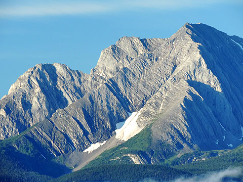
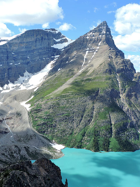
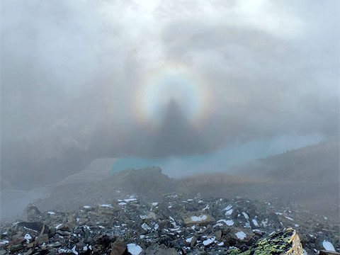
Recent route photos taken by Alan
|
|
|
|
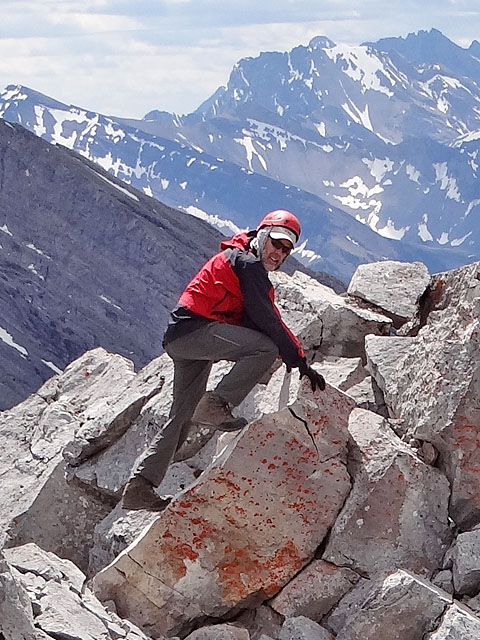 I took this photo of Alan on Mount Lawrence Grassi (2014) |