bobspirko.ca | Home | Canada Trips | US Trips | Hiking | Snowshoeing | MAP | About
Longwell Peak
aka Fire Peak
Lake Mead NRA, Nevada
January 20, 2015
Distance: 8.8 km (5.5 mi)
Cumulative Elevation Gain: 851 m (2792 ft)
From the roadside, we could see little of the route up Longwell Peak. Cliffs and ridges hid the washes and canyons we needed to hike up. Even the summit, just a slight curve on the skyline, was difficult to spot. The only thing we could see clearly was the desert flats ahead that stretched for a kilometre to the base of the mountain. I was glad we didn't have to determine the route then and there: Harlan Stockman had laid it out on his website.
Shin, Dinah and I started across the flats, heading towards the cliffs below the pass we needed to reach. Keeping right of the cliffs, we had no difficulty reaching the pass. On the other side, a wash drops into a delightful canyon. We followed the canyon until it flattened into a wash. We couldn't miss the truck-size boulders that mark the exit from the canyon/wash. Above the boulders a wash splits. We ascended the wash on the right, but the left wash, which we later descended, turned out to be easier and more colourful (the map at the bottom depicts our descent route). Either way, it was important to gain the shoulder above us so we could see the entrance to a slot canyon.
Up until that point, our trip had been largely an offtrail hike, but in the confines of the slot canyon, steep walls presented bits of class 3 scrambling, more interesting than challenging. Shortly we emerged onto a wash. In the distance we could see our next objective, a saddle. The summit on the left was hidden. We slowly made our way to it.
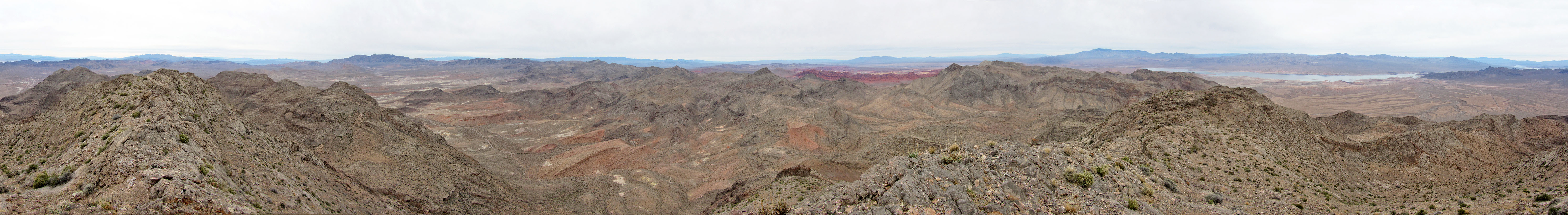
From the summit we had fine views all around, but the most splendid sight was the line of crimson peaks in the Valley of Longwell. Perhaps it's this scene that gives the mountain its name, for we saw nothing fiery about Longwell Peak. And despite its fierce-sounding name, it was an enjoyable climb filled with satisfying scenery.

Starting across the desert flats. Longwell Peak is on the right, well in the back.

We headed to the low, buff-colored ridge on our right

From the low ridge we made our way to the right side of the nearest cliffs

After keeping right we found a weakness in the cliff band. There was even a cairn at the top!

Looking back after we climbed up the weakness

Heading to the pass

On the other side of the pass we followed a wash down to a canyon

In the canyon

We passed impressive conglomerate boulders

We left the canyon, now a wash, when we spied these boulders

Above the boulders, the wash diverges. We ascended the wash on the right but descended
the one on the left. I recommend taking the left wash (note the green wall left) for both ways.

Looking back

Heading to the shoulder

From the shoulder we made our way to a slot canyon to the right of the large cave

Entering the slot canyon

This was a fascinating canyon to ascend

Shin waits for us in the canyon

We passed a couple of small caves

After emerging from the slot canyon we can see the saddle well in the distance. The summit is
left, out of sight.

The slog to the saddle seemed interminable and there's still no sign of the summit

Looking back at the wash that leads to the saddle

Almost at the saddle

From the saddle the Valley of Longwell appears in the foreground while Moapa Peak rises behind

Looking back at the saddle as we headed to the summit

Posing on top of Longwell Peak

Coming down from the saddle

Back in the slot canyon, Shin starts down a tricky section. After dropping
down a short way he'll traverse the ledge on left.

After reaching the shoulder, we kept right and descended a different wash than we ascended

Looking back up the wash to the shoulder

Some unusual rock formations line the right side

Farther down we found a striking, green wall

Dinah joins me by the green wall

Back in the wash where our descent and ascent washes can been seen above the boulders

Bitter Spring and Echo Bay (5.5 mi, 3940 ft, 2054 ft)
