bobspirko.ca | Home | Canada Trips | US Trips | Hiking | Snowshoeing | MAP | About
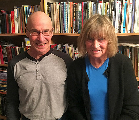
A Conversation with Gillean Daffern, author of Kananaskis Country Trail Guide Whenever I step onto any trail in Kananaskis Country, I know that chances are near certain that Gillean Daffern has been there many times before me. Gillean is the author of Kananaskis Country Trail Guide, a long-established guidebook on hundreds of main trails and their branches in the popular park. |
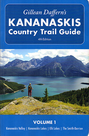 Volume 1 of the latest edition of Kananaskis Country Trail Guide |
My first Kananaskis Country Trail Guide books, the two-volume third edition, are dog-eared from use, and I am slowly becoming familiar with the five-volume fourth edition. But I hadn’t given much thought about the author, that is until I learned she is attributed to doing many first ascents. With that, I became curious about Gillean’s background. So I called her and arranged to sit down and have a chat. I suggested doing an interview, but admitted I hadn’t done one before. She laughed and said she had never been interviewed before. I guess that put us on equal but shaky footing. But we both agreed it would be fun. Gill greeted me at the door and led me into the office where her husband Tony was sitting in front of an iMac, working on their website, Kananaskis Trails. He pointed out an old map displayed on a web page, a map he scanned from their copy of a 1920 book by Canadian Surveyor Oliver Wheeler. It turns out, Gill and Tony have an extensive library: bookcases crammed with hundreds of books including guidebooks, mountain history and old photo albums. Then Gill and I sat down. I set out my smart phone to record our conversation. Without either of us really understanding our roles, and with both of us often laughing at her recollections, I somehow managed to learn about her past. Gill’s story (in bold) begins in the UK, at Sale near Manchester where she was born. Soon after, the family moved to the city of Leicester where they sat out World War II. Nearby was Charnwood Forest where her uncle lived. As soon as I could walk my uncle would drag me out for long walks over the hills and tire me out. He was interested in nature and in history, so he’s responsible for a lot of what I am now. Then we moved back to Sale, quite close to the Moors and Gritstone Edges, a hiking and climbing area. I went out a lot by myself even at a very young age. At eight I used to bike or take a bus out to places like Kinder Scout and Bleaklow. I don’t know how my mother and father coped with me actually. I used to go out by myself in all kinds of weather, and that’s how you learn to navigate in thick mist and become self-reliant. Sometimes I was on trails but often not. I remember getting a rope for Christmas once. When I was in grammar school, a group of us got together and did all kinds of trips. We used to bike somewhere and then go hiking or caving in disused copper mines. It’s a wonder we didn’t kill ourselves. Later I joined a youth hostel group, mostly a walking club. A few of us went out to the Edges and did easy climbs. When I was in my middle teens, I was conscripted into a climbing club. I did quite a bit of rock climbing, mostly on gritstone, but was only ever middling. I didn’t find it as much fun as previously, and didn’t like the competitive aspect. I decided I much preferred long distance exploring into wilderness areas where I had never been before. Like most people, I went to the Zermatt Alps (in Switzerland) and climbed about five peaks there. I didn’t particularly like the Alps. While the mountains were beautiful, I didn’t like the hordes of people on the trails, in the huts and on the routes. It just didn’t appeal to me. I found the Pyrenees much more to my liking. Gill then turned to isolated places. When she was 21, she and a few climbing friends took a month-long walk from the Baltic Coast through Sweden, crossing big rivers and icefields, and climbing peaks along the way to the Norwegian coast. They reached the Lofoten Islands, a major rock climbing area. It was the first of Gill's three visits to these islands. In 1960, when she was 22, Gill went on a climbing expedition to Spitsbergen, an island 500 miles from the North Pole. The trip was notable for two reasons: she met Tony, and she had her first and only climbing accident. There were two climbing expeditions going to Spitsbergen, but when people dropped out of both, we decided to amalgamate. There were six of us, including a couple of mountain guides that we knew. We all met in a pub in Derbyshire. That’s when I first met Tony. We had a close call on that trip. The idea was to ski from one mountain group to another while pulling sleds behind us. We were supposed to pick up the sleds in Norway on our way out there, but they never arrived. So when our fishing type boat dropped us off in Spitsbergen, our first job was to make two sleds out of crates that had held our food. We had to use our skis as sled runners, so we ended up pulling the sleds on foot. We also had to make harnesses to use when pulling our sleds, but of course they were not the quick release type we had ordered. So what happened is that one day we were traveling up this really big glacier and the weather was getting bad; mist was coming down. Three of the group were pulling the first sled ahead of us. While following their tracks across snow-filled crevasses, our sled went right through a big one. Luckily the sled jammed at a narrow point in the crevasse about a hundred feet down. Tony and I landed on a tiny ledge. I think it was the snow that had come down from the top. HM was dangling from his harness below the sled. Somehow we retrieved a rope from the sled and used it to bring him up to our ledge. Most everything else had fallen off the sled. All our food was scattered down the side of the crevasse. It looked like the inside of a fridge and I took some photos of it. It fell to Tony to get us out because he was by far the best climber. He did an amazing job. Luckily he still had his ice axe in his hand when he landed and I still had mine, despite bashing myself up with it during the fall. So I was able to belay him from our ledge, worrying all the time that if he fell the whole ledge would give way and fall into the depths. Meanwhile, the first group had gone ahead and camped. After HM and I climbed out of the crevasse belayed by Tony from the top, we followed the first group’s tracks to where they were camping. The others hadn’t realized what had happened to us. We went back the next day and retrieved what we could, but we only had one sled after that. Even though we had lost a lot of stuff, we did fine. We climbed several more peaks and continued crossing big glaciers although rather more cautiously. I remember one occasion when a crevasse started opening up under our tent! Gill and Tony got married while still in the UK and had a son. In 1966 they moved to Canada, first to Edmonton to be close to the mountains near Jasper. Gill was dismayed that it took 3,000 feet of climbing through trees to get to the open slopes. This is why she is continually on the lookout for open ridges that are readily accessible. She later learned to love the forest. Tony had a job as a highway engineer so for the first five years we moved 15 times around Alberta. We lived in Banff and Canmore. For two years we were out on the David Thompson Highway. We did a lot of first ascents off this highway and along the Icefields Parkway, climbing some of the remoter peaks over 10,500 feet (3200 m). I don’t know if they have names now. We were looking for all the unclimbed, unnamed ones. Gill wasn’t out there to make an impression; she pursued remote, unnamed peaks just for the adventure and the challenge. Even a chronic knee problem didn’t deter her from climbing. While living in Banff, a Banff surgeon made a mess of a simple knee operation. Ever since then I haven’t been able to bend my left leg very far, despite a second operation by a different surgeon that got the bend to about 89 degrees. So if I’m on a scramble and have to step up high, I have to use my right leg. The problem is that in the last few years, because my right leg has been doing all the work, my right hip is now going on the blink. So now I’m into cortisone shots and taking painkillers whenever I go out. But you do what you have to do because you want to get out in the mountains. In the early 1970s, Gill and her family moved to Calgary where Tony got a job teaching at SAIT. (She regrets he didn’t stay longer with Alberta Highways because the next job coming up was Hwy. 40!) From Calgary they extensively explored the mountains and foothills that was to become part of Kananaskis Country. Then in 1978 Gill got the idea of writing a guidebook when the opening of Kananaskis Country was announced. Tony and I had been to a party and as we were driving home I said to Tony, "You know what, someone is going to write a hiking guide for this new place called Kananaskis Country and it might as well be me." We had done a lot of things in that area, together with a few other people we knew like Alf Skrastins. We decided to publish the book ourselves. I had a masters degree in book design, illustration and graphic design from the Manchester School of Art, so it was something I was familiar with. At that time there were no personal computers and it was very slow business working with Rubylith masking tape and Letraset. Drawing contour lines on maps was a real pain. Anyway, the first book came out in 1979 and only cost $5.95. It has in it a lot of the same trails we use nowadays. The first edition of Kananaskis Country Trail Guide had 158 pages and 140 trail descriptions. Like all her editions, the trails were numbered and the book had maps in the back. That was the first book, but long before then I had been running a business on the side, selling used mountaineering books throughout the world. It was called Rocky Mountain Books. In 1979 I started a publishing company with the same name, shortened to RMB, and used a mountain goat picture courtesy of Don Beers as the logo. I went about three years on my own. Then Tony left his well-paying job to see if we could make a go of being a publisher, which we did. In 1980 RMB came out with their second book, Waterfall Ice by Albi Sole. It was the first ice climbing guidebook in the world. This was followed in 1981 by The Magic of Lake O’Hara and Tony’s Avalanche Safety for Skiers and Climbers. RMB moved the business out of the house into new premises and had seven staff working for them. For many years after, I spent nearly all my time working on other people’s books doing editing and layout. I was really happy when the books won awards or when a writer achieved his or her dreams to become a full time author. And RMB was thriving, filling a niche, not only in the genre of guidebooks but also in history and biographies pertaining to the Rockies. I simply had no time to attend to Kananaskis Country Trail Guide. But finally in 1986, the second edition came out. It was still one volume and included ski trails. In 1992 all the ski trails went into Kananaskis Country Ski Trails. Two years later I put all the interpretive trails into Short Walks for Inquiring Minds. Then in 1997 I expanded to a two-volume 3rd edition, and since then to the five-volume 4th edition which is the latest Kananaskis Country Trail Guide. It must be a doddle writing a guide to a national park, but nothing in K-Country stays the same for long. Here I have to deal with ongoing logging, the opening and closing of resource roads, constant new trail building, and last but not least, the havoc caused by the 2013 flood. I have a revised edition of Volume 5, the Highwood Area, coming out in the spring of 2017. But it’s going to take a few years to update the other volumes. I have lists of trails I have to go and look at. I’m still working my way through them. I’m still waiting for many trails to be fixed up after the flood, such as Big Elbow Trail. Also in the Elbow, there has been so much new trail building, I will probably be adding another 28 pages to Volume 2. And some trails, unaffected by the flood, are still being improved for other reasons. Scramblers will be super happy to know that the trail around Hidden Lake together with its accesses has been officially cleared, and a new trail built up that first little headwall. Gill hits the trails twice a week, still checking things out and looking to improve routes. In the previous month, for instance, she climbed Windtower using a new, shorter trail that bypasses West Wind Pass. People have made a trail going straight up Windtower. It’s pretty good most of the way. And I think people are going to like it because it’s shorter and real fast on the descent. You’re not going to the Pass anymore unless you want to do a loop. Then Gill suddenly switched the conversation to travel. I knew she travelled from when I paid her a visit a couple of years ago, just after she and Tony had been to Iceland, camping and climbing mountains. Now she wanted to drive the point home that they love to travel. Everyone seems to think I spend all my time in Kananaskis Country. Not so. We’ve hiked a lot in the northern Rockies between Jasper and Kakwa, climbing peaks first ascended by the boundary survey. Outside of Canada, we’ve been to many far off lands including Peru, Namibia, Tierra del Fuego, Tibet, the island of South Georgia. We went to Cuba last spring. And Japan a few times. My favorite story from these trips centers on the island of Dominica in the Caribbean. Gill and Tony also go on kayaking trips, going for a couple of weeks at a time and camping along the way. We took up sea kayaking about 15 years ago. We go out to the ocean once a year to do some sea kayaking, pretty well anywhere we can drive with our sea kayaks. We went kayaking on Lake Powell in Utah in October a few years ago. Last year we went to Haida Gwaii. Our longest trip took three weeks. We took our sea kayaks down the Red Deer River from the Dixon Dam near Innisfail through the badlands into Saskatchewan. Our kayaks are kind of small. We can only carry twelve days of food maximum, plus four days of water, so we had to stop at Drumheller to get more groceries. Now in her late 70s, Gillean remains active in the mountains and has no plans to retire. Some years ago she and Tony sold RMB but Gillean continues to work for them, often for free as she wants their business to do well. And of course, she continues to work at keeping Kananaskis Country Trail Guide up-to-date. The next time you hike up a trail in K-Country, think of Gillean. Without her work, you may not have even known that trail existed. |
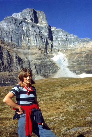
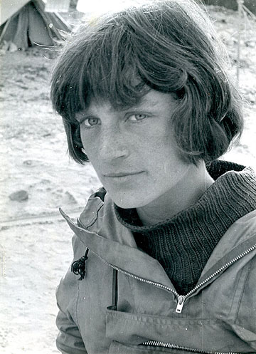 Gill at age 22 |
|
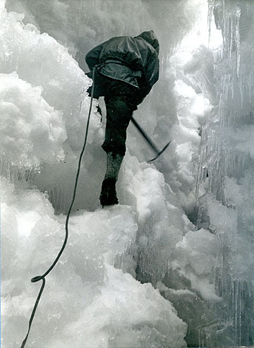 Tony begins climbing from their ledge in the crevasse (1960) |
|
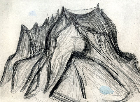 Gill's sketch of an unnamed peak they climbed on Spitsbergen. She did – and still does – lots of drawings. |
|
 In the Rockies (1978) |
|
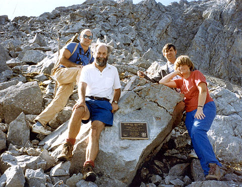 Tony and Gill with friends by the official plaque on Belmore Browne Peak (1993) |
|
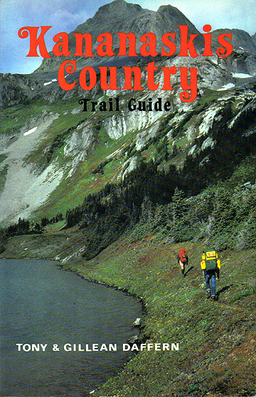 The first edition of Kananaskis Country Trail Guide was published in 1978 |
|
|
|